What Is Downtown Boston? - A Neighborhood Guide
What “Downtown Boston” Actually Means
(And how its neighborhoods really fit together)
People talk about Downtown Boston as if it’s one place. In reality, it’s a compact, highly walkable core made up of several distinct areas that overlap in function more than in name. Downtown is where Boston’s daily systems converge — offices, transit, government, culture, shopping, and foot traffic — often within the same few blocks.
It’s less a single neighborhood and more a tightly layered center defined by how the city works and moves, rather than where people primarily live. Streets are older and irregular, blocks are dense, and activity stacks vertically and horizontally in ways that make downtown feel larger than it looks on a map.
- WEST: Boston Common & Downtown Crossing
- EAST: The Financial District & Waterfront
- NORTH: Haymarket, Government Center & the Greenway
- SOUTH: Chinatown, the Theater District & South Station
Measured across those edges, Downtown Boston loosely totals around 1.5-2.0 square miles.
- East–west: ~0.7–0.8 miles
- North–south: ~0.9–1.0 miles
Wait, It’s Only About 1.5-2 Square Miles?
On paper, downtown is compact. On the ground, it feels expansive. That’s because density here is concentrated rather than spread out. Buildings run taller than in most Boston neighborhoods, streets are narrow and layered, and multiple districts overlap within a short walk. Major transit hubs funnel people and destinations into the same blocks, compressing activity and making downtown feel busier, larger, and more complex than its footprint suggests.
Each part of downtown also contains its own micro-areas that feel noticeably different once you’re moving through them — shaped by transit patterns, institutions, and daily routines rather than residential life.
What's NOT Downtown?
Downtown Boston isn’t a catch-all for nearby neighborhoods. Places like the North End, Back Bay, Beacon Hill, and the West End are close and easy to walk to, but they function on their own and aren’t part of downtown itself. Big-name shopping areas like Newbury Street and the Copley Place area often get lumped in because they’re busy and well known, but they’re firmly part of Back Bay. Downtown is defined less by what’s nearby and more by what actually runs through it every day.
The West Edge: Boston Common & the Downtown Gateway
This is where downtown starts to breathe. Office towers and retail blocks ease up at the edge of Boston Common, creating a rare mix of open green space, major transit connections, and nonstop foot traffic. Covering roughly 0.5–0.75 square miles, this area works as downtown’s western entry point.
How This Part of Downtown Feels
Busy, transitional, and always moving. This isn’t a place people hang out all day — it’s a place they pass through. Commuters cut across the Common, people switch T lines, meet up, grab coffee, and keep going. Weekdays are the most active, with things slowing down noticeably in the evenings and on weekends.
Who lives here
- Very few full-time residents, mostly in newer or converted downtown buildings
- Most of the people you see are commuters, students, and visitors moving between transit, offices, shops, and the Common
- Foot traffic follows work and transit schedules more than neighborhood routines
Buildings & scale
- A mix of historic mid-rise buildings and taller office towers
- Streets feel tight and crowded near Downtown Crossing and Park Street
- The edge opens up at the Common, where green space breaks up downtown’s density
Key landmark buildings & attractions
- Boston Common – The city’s central green space and historic anchor
- Park Street Station– One of Boston’s busiest and most critical transit hubs
- Downtown Crossing retail district – Pedestrian streets and major shopping corridors
West Neighborhoods & Micro-Area
Downtown Crossing (western edge)
This is downtown's most concentrated everyday retail and transit hub, built around efficiency rather than luxury. Pedestrian-only streets like Washington and Winter pack national mid-market retailers, legacy department stores, and practical services into a few dense blocks, with fast-casual dining and coffee threaded throughout. Multiple MBTA lines converge here.Park Street Area
Anchored by Park Street Station, one of the most important transfer points in the MBTA system. It sits directly between downtown retail and the Common, acting as a daily funnel for commuters, students, and visitors .Its location at the edge of Boston Common creates a clear transition: dense retail and office blocks on one side, open green space on the other.
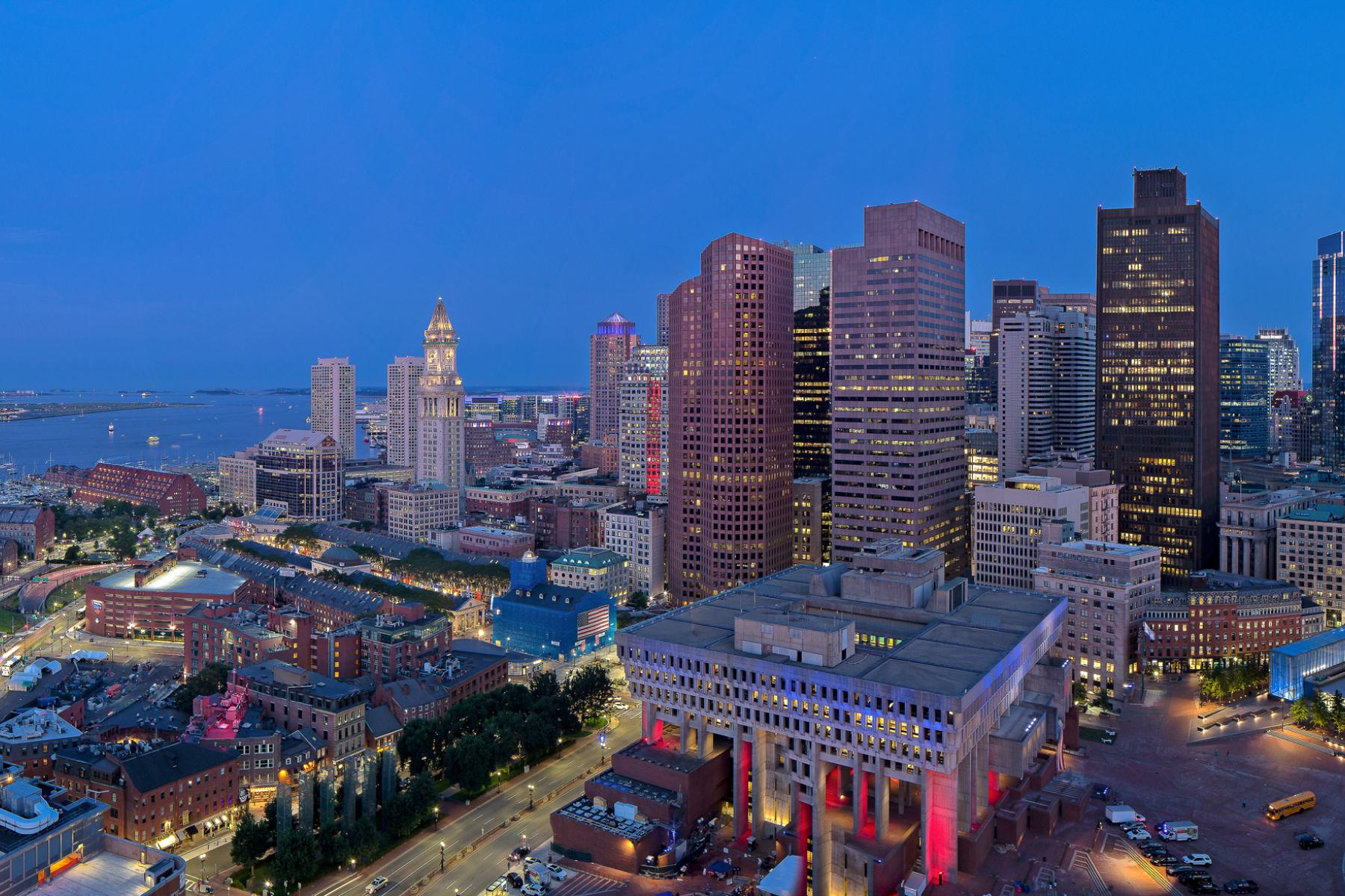
The East Edge: Where Downtown Hits the Water
This is Downtown Boston at its outer edge, where the Financial District gives way to the harbor. Office blocks start to break up, streets open toward the water, and the city feels less sealed in. At roughly 0.5–0.75 square miles, this slice of downtown acts as a transition zone linking the business core with the waterfront and ferry routes.
How This Part of Downtown Feels
More deliberate and work-driven, shaped by historic buildings, financial district high-rises, narrower streets, and other long-established institutions. The amosphere changes towards the harbor: buildings step back, light opens up, and the water becomes a constant presence.
Evenings have a calmer rhythm, with people walking the Harborwalk, ferry traffic coming and going, and dinner crowds that feel more laid back. It’s still downtown, but with more breathing room and a clearer edge.
Who lives here
- A mix of older mid-rise commercial buildings and taller high-rise towers, especially through the Financial District
- The Financial District remains the primary high-rise cluster in downtown Boston
- Streets feel tight and vertical inland, then open up as you move toward the harbor, wharves, and ferry terminals
- The waterfront lowers the perceived scale, with wider views and longer sightlines
Buildings & Scale
- A mix of older mid-rise commercial buildings and taller high-risetowers, especially through the Financial District and Government Center edge
- The Financial District is the primary high-rise cluster in downtown Boston.
- Streets feel tight and vertical inland, then open up as you move toward the harbor, wharves, and ferry terminals
- The waterfront lowers the perceived scale, with wider views and longer sightlines
Key Landmark Buildings & Attractions
- Boston Harbor – The defining edge of this area, shaping everything from street layout to daily movement
- Long Wharf – A major ferry hub and one of the clearest connections between downtown and the water
- New England Aquarium – A constant draw that brings families, tourists, and locals to the waterfront year-round
- Custom House Tower – A visual anchor of the skyline and a reminder of the area’s maritime roots
- Faneuil Hall & Quincy Market – A high-traffic crossroads for food, shopping, and pedestrian movement between downtown and the North End.
East Neighborhoods & Micro-Areas
Financial District
This is downtown at full working speed. Streets are tight, buildings run tall, and daily life centers on offices, courts, and government buildings. Weekdays are busy and efficient, with lunch spots and coffee shops doing most of their business before early evenings quiet the area down.Faneuil Hall & Quincy Market
This area functions as a historic civic core and a large public market rather than a neighborhood in the residential sense. Faneuil Hall is an active public meeting hall and event space, while Quincy Market is an enclosed food hall with casual dining and vendors. Together, they create one of downtown’s busiest pedestrian zones and act as a connector between the Financial District, the waterfront, and the North End.Waterfront & Long Wharf
This is where downtown physically meets Boston Harbor. Long Wharf and the surrounding piers are working transportation hubs, home to ferry service, harbor cruises, and water taxis. The area also includes the New England Aquarium, harborwalk paths, hotels, and waterfront dining. It stays active beyond office hours, especially on evenings and weekends, with people walking the water’s edge or heading to boats and restaurants.
The North Edge: Haymarket, Government Center & the Greenway
This is downtown Boston at its northern boundary, where the commercial core meets major civic infrastructure rather than a residential neighborhood. The north edge is defined by transit, government buildings, markets, and open space — a functional seam between downtown and adjacent neighborhoods rather than a lived-in district itself. At roughly 0.5 square miles, it operates as a gateway zone rather than a destination.
How This Part of Downtown Feels
Highly transitional and infrastructure-driven. This is a part of downtown shaped by movement: people arriving by transit, running errands, passing through markets, or cutting across the Greenway. The street pattern is irregular and older, but activity is governed less by neighborhood routines and more by daily circulation. Evenings quiet down quickly compared to other edges.
Who Lives Here
- Very few full-time residents within the downtown boundary.
- Most daily users are commuters, city employees, market shoppers, and people transferring between transit lines.
- Nearby residential neighborhoods influence foot traffic, but the area itself remains primarily commercial and civic in function.
Buildings & Scale
- A mix of mid-rise historic structures and large-scale civic buildings
- Open plazas and infrastructure-heavy blocks create visual breaks in the street wall
- Government Center introduces wide setbacks and larger footprints compared to other downtown areas
- The Greenway lowers perceived density, even as surrounding blocks remain active during the day
Key Landmark Buildings & Attractions
- Haymarket– A long-running commercial crossroads where produce vendors, transit access, and downtown foot traffic converge at the edge of the North End.
- Boston Public Market – A year-round, locally focused market anchoring the Haymarket area with groceries, prepared foods, and regional vendors.
- Government Center – A concentration of municipal buildings and civic space that defines the institutional character of the area.
- City Hall Plaza – A large public plaza used for events, seasonal programming, and civic gatherings.
- Rose Kennedy Greenway – A linear open-space corridor that buffers downtown from major roadways and provides pedestrian connections north and south.
North Neighborhoods & Micro-Areas
Haymarket / Blackstone Block
This is one of downtown’s most utilitarian zones. Activity here is driven by markets, transit access, and daily errands rather than leisure. Foot traffic is steady and practical, shaped by commuting patterns and shopping needs rather than office hours or nightlife.Government Center Core
Defined by large civic buildings and open plazas, this area feels formal and institutional. It plays a critical role in how downtown functions administratively, but it does not operate as a neighborhood in the residential sense.Greenway Edge (North End Side)
Along the northern stretch of the Rose Kennedy Greenway, the scale opens up without becoming residential. This edge functions as a buffer and connector — a place people move through, pause briefly, or cross between districts, rather than a place they stay.
The South Edge: Chinatown, the Theater District & South Station
Downtown Boston’s southern edge is where daily life, culture, and infrastructure overlap most tightly. This is not a peripheral zone—it’s a dense, active seam connecting the office core to residential streets, major transit, and some of the city’s most concentrated cultural venues. Roughly 0.5–0.75 square miles, the south edge is shaped as much by movement and performance as by neighborhood life.
How This Part of Downtown Feels
Lived-in, layered, and active beyond office hours. Daytime brings a steady flow of commuters through South Station and Downtown Crossing’s southern blocks, while evenings shift the energy toward restaurants, theaters, and nightlife.
Unlike the Financial District, this part of downtown doesn’t fully shut down after work. Foot traffic thins but doesn’t disappear, especially around Tremont Street, Washington Street, and Kneeland Street, where dining, shows, and late hours keep the area moving.
Who Lives Here
- A meaningful residential presence, particularly in Chinatown and along the edges of the Theater District.
- Longtime residents alongside renters in mid-rise residential buildings and mixed-use blocks.
- Daily users include downtown workers, theatergoers, students, and regional commuters moving through South Station.
- The neighborhood mix feels stable and local, even with heavy daily visitation.
Buildings & Scale
- Predominantly mid-rise buildings, with a mix of historic masonry structures and newer residential towers
- Streets are narrow and tightly framed, especially through Chinatown and along Tremont and Kneeland
- Few true high-rises, but visual density remains high due to closely packed blocks and limited setbacks
- South Station introduces larger civic scale, but surrounding streets quickly return to human proportions
Key Landmark Buildings & Attractions
- Chinatown Gate – A ceremonial gateway marking the neighborhood’s cultural core
- Boch Center Wang Theatre – A major performing arts venue anchoring the Theater District
- Emerson Colonial Theatre – One of Boston’s oldest continuously operating theaters
- The Wilbur Theatre – A long-standing venue for comedy and live performance
- South Station – Downtown’s primary rail and bus hub, linking Boston to the region and Northeast Corridor
- Tufts Medical Center – A major institutional presence shaping daily activity on the south edge
South Neighborhoods & Micro-Areas
Chinatown
One of downtown’s most established and lived-in areas. Chinatown is dense, residential, and culturally specific, with housing above ground-floor restaurants, bakeries, markets, and shops. Streets like Beach, Tyler, and Kneeland stay active throughout the day and into the evening, driven by local residents as much as visitors. The neighborhood feels compact and continuous, with little separation between daily life and commercial activity.Theater District
Centered along Tremont and Washington Streets, the Theater District has more evening and weekend energy. Performance venues anchor the area, but the surrounding fabric is made up of restaurants, bars, and smaller clubs. Activity here peaks after work hours, and sidewalks stay busy late, especially near major theaters and nightlife venues.South Station & Dewey Square Edge
Downtown’s most infrastructure-heavy zone. South Station is both a major transit hub and a working public space, with a steady stream of commuters, travelers, and office workers moving through all day. Dewey Square and the surrounding blocks absorb that flow, bridging transit, offices, and Chinatown. Foot traffic here follows train schedules more than dinner plans, but it’s essential to how downtown runs day to day.
The Sudbury: Downtown Boston
Luxury new apartments at The Sudbury are located within Bulfinch Crossing, a large-scale redevelopment reshaping the northern edge of downtown Boston. Built on the former Government Center Garage site, Bulfinch Crossing introduces new residential buildings, offices, streets, and public spaces designed to reconnect this part of downtown to its surrounding neighborhoods.
From The Sudbury, Haymarket, Government Center, and the Rose Kennedy Greenway are all within a few blocks, placing the building inside downtown’s civic and transit core, while the West End begins just to the west with a quieter, more residential feel. The result is a location that sits squarely within downtown while also acting as a bridge to the neighborhoods around it.
![]Sunlit living room at The Sudbury in downtown Boston, with floor-to-ceiling windows overlooking surrounding Financial District office towers and the city skyline. The space features a modern sofa, accent chairs, wood coffee table, area rug, and an open kitchen and dining area with wide-plank flooring.](https://cdn.carmel-apartments.com/system/uploads/fae/image/asset/36017/financial-district-views.jpg)